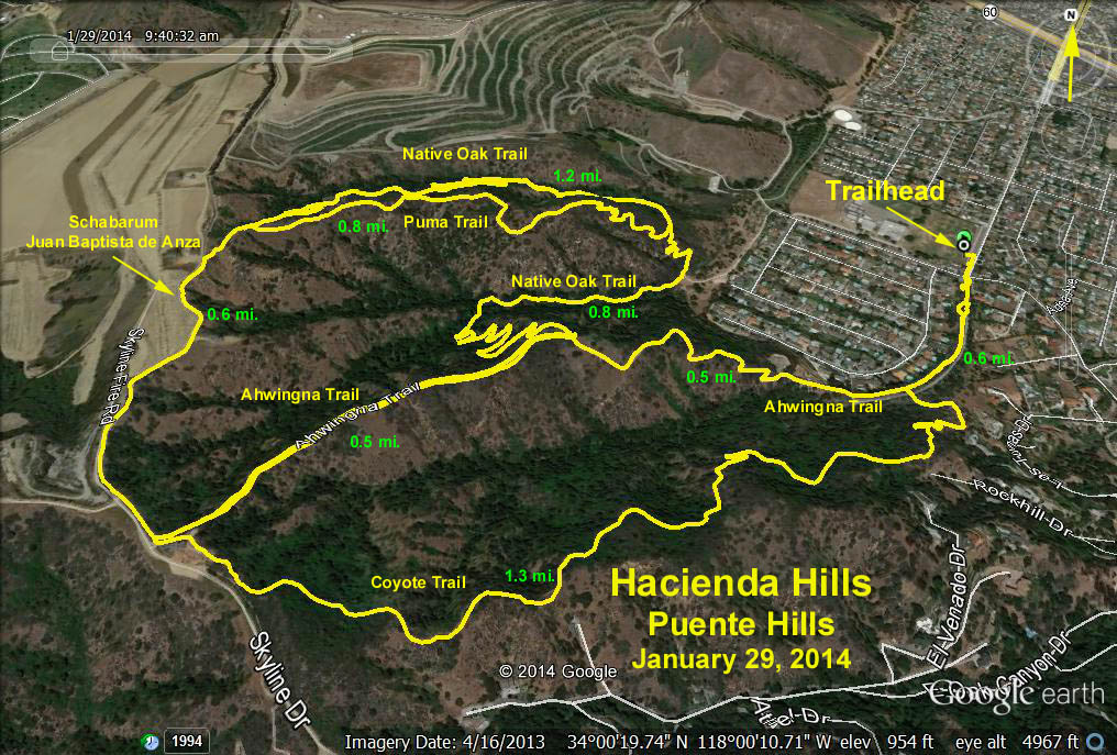
GPS Data:
Outside loop 5.6 miles RT and 830 ft.
North loop 5.3 miles RT and 830 ft.
South loop 3.5 miles RT and 830 ft.
Directions to Trailhead:
From the West Valley take the 101 south to the 5, then east on the 60 to 7th Avenue. Go South on 7th Avenue to Orange Grove Ave. There is a small parking near this intersection. If full you may park along Orange Grove Avenue.
From the South Bay come east on the 91 to the 605 then north on the 605 to the 60 then as above.
The hike: You will travel through varied terrain, from canyon bottoms to high ridges. The outside loop goes up steeply 0.8 miles from the trailhead on the Ahwingna Trail to a junction with the Native Oak Trail. Go right on the Native Oak Trail. In 1 mile you will arrive at a junction with the Puma Trail. Go right and continue on the Native Oak Trail 1.2 miles to the top of the ridge to the trail which is at present referred to as the Schabarum or the Juan Bautista de Anza National Historic Trail and formerly was known as the Skyline Trail. Turn left here and go 0.6 miles to a junction with the Coyote Trail. Go left 1.5 miles back to the parking lot.
The north loop goes right at the Ahwingna - Native Oak Trail Junction 2.2 miles to the top of the ridge. Turn left and in 0.5 miles you will reach the Ahwingna Trail. Turn left and then go 1.3 miles back to the parking lot.
The south loop goes left at the Ahwingna - Native Oak Trail junction 0.5 miles up to the top of the ridge. A left turn takes you in 0.1 miles to the Coyote Trail and then back to the parking lot.
There is a restroom at the trail head. Refreshments will be close by. Maps will be provided.