Distance: 7.5 miles RT. Shorter options at 2.3, 4.1 or 6.4 miles.
Elevation gain: 1170 ft.
Directions to Highridge Park: 405 south to Crenshaw exit. Turn right (south) 8 miles to Crestridge Road (light). Turn right, proceed 0.5 miles to end. Turn left; proceed 0.1 mile to park entrance on the right. Restrooms are available at the park
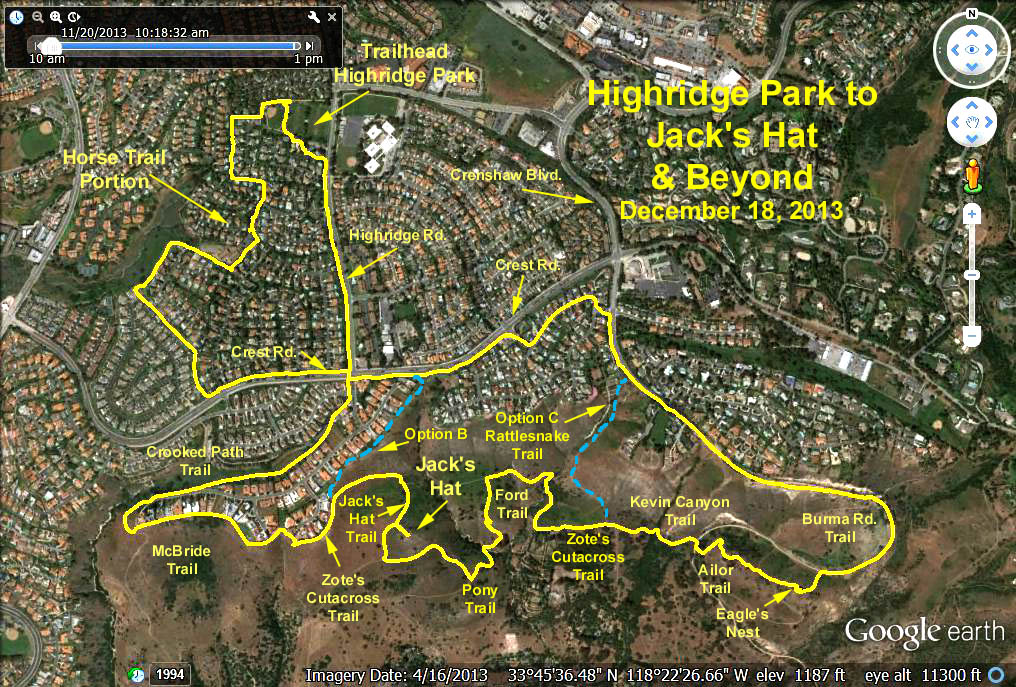
The Hike: For the first 1.4 miles of this 7.5 mile hike we'll be on horse trails (click HERE for details).
We cross Crest Road and walk the path to Highridge Road where we turn right for a short distance and join the Crooked Patch Trail which connects to the McBride Trail with its panoramic view of the south side of the Peninsula, the Pacific Ocean and Catalina Island. We continue on the McBride trail to Zote𠏋 Cutacross Trail where we descend to the Jack𠏋 Hat Trail and then go up to Jack𠏋 Hat where we have a great view.
Leaving Jack𠏋 Hat we continue on the Jack𠏋 Hat Trail to the Pony Trail where we descend to the Ford Trail which drops down and through a dry stream bed then climbs back up to Zote𠏋 Cutacross Trail. We then head east to the Kelvin Canyon Trail eventually reaching the Burma Trail. We jog right and connect to the Ailor Trail where we go up to Eagles Nest - a great place to survey the coastline and eat lunch.
From there we take the Burma Trail to Del Cerro Park and continue up Crenshaw Blvd to a residential area where we head west on Santa Barbara Dr. We turn right through a gate at Whitley Collins Dr. which connects to a sidewalk along Crest Road, then head left to Highridge Road. Finally we walk along the bike path back to Highridge Park where we will have refreshments.
Option A 2.3 mi RT: Horse Trails to Crest Road, turn left and walk the sidewalk to Highridge Road, turn left and proceed north to the park entrance on your left.
Option B 4.1 mi RT: Horse Trails to McBride Trail per above - except do not turn at Zote's Cutacross Trail, but continue on McBride Trail until reaching Crest Road, turn left to Highridge Road, turn right crossing Crest and proceed north to the park entrance on your left.
Option C 6.4 mi RT: Basic Hike except depart Zote's Cutacross Trail where it intersects the Rattlesnake Trail (beyond the Ford Trail detour). Go north on the Rattlesnake Trail as it steeply climbs up to Crenshaw Blvd., turn left and continue back to the park per above.
Google Earth photo - Highridge Park to Jack's Hat & Beyond
GPS Data:
Distance = 7.5 mi RT
Max Elevation Gain = 560 ft.