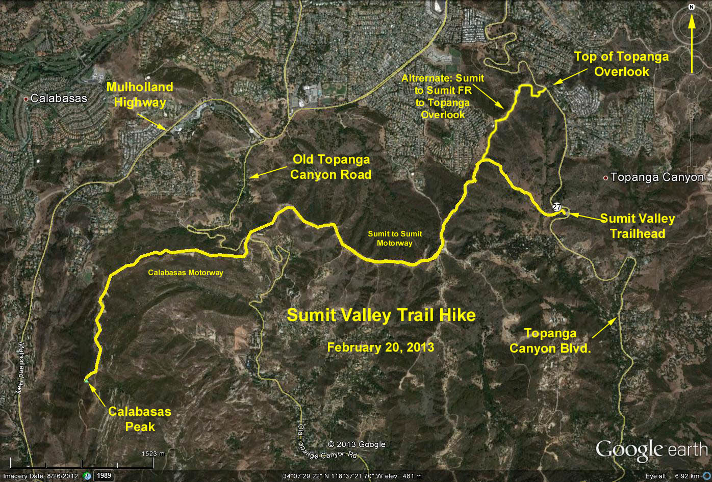
Basic Hike: 10.5 mi. RT, max. elevation change = 1000 ft
Alternate Start from Top of Topanga: 10.5 mi. RT, max. elevation change = 600 ft.
Directions to Trailhead: From PCH drive north up Topanga Canyon Road, through the village, then approximately a mile or so past Entrada Road look for a parking lot on the left (west) side of the road.
From the Valley, drive south on Topanga Canyon Blvd. At approximately 1 mile south of the Top of Topanga summit, look for the parking lot on the right (west) side of the road. The trailhead is called "Summit Valley - Edmund D. Edelman Park." There is a restroom at the trailhead. There is also a $5 parking fee (cash only).
The Hike: The trail head is near the south end of the parking lot. The trail descends to the canyon bottom then rises, getting steep and rutty for a ways until it reaches the Summit-to-Summit fire road. There are two forks encountered along the way. Take the left fork each time and continue straight ahead up the ridge.
Turn left (westerly) upon reaching the fire road, noting the post on the right as a marker for your return. The hike continues only on fire roads (Motorways) from here to Calabasas Peak which are public access roads regardless of what local property owners have posted. Just make sure you stay on the fire roads.
Proceed along the fire road, going around the locked vehicle access gate until you come to a four-tine fork. Take the right-most tine, step over the gate and continue west on the Sumit to Sumit Motorway. Cross Old Topanga Road (at about 3 mi.) and continue, now on the Calabasas Motorway. At about 5 mi. and 150 yards beyond the obvious high point that is Calabasas Peak, look on your right for the use trail to the peak which rises only 100 feet above the Motorway. Return the way you came.
When driving out of the parking lot, use extreme caution since visiblity is very limited in both directions due to the bend in the road.
Alternate Hike: For those wishing a less strenuous hike with less elevation change free from the steep rutty trail segment, you may start the hike at the fire road gate of the Summit to Summit Motorway located across from the "Top of Topanga" view point on Topanga Canyon Road (approximately 1 mile further north of the hike trailhead) and continue as far as you wish. Park at the view point across the road. There is no fee, and no restroom and there are only 14 parking spaces that are usually pretty full. Entry to the view point parking lot is from the south only. Exit from the view point parking lot is toward the north only.
PLEASE NOTE: If you take this option you will have to drive down to the Summit Valley trailhead for refreshments.
Google Earth Photo - Calabasas Peak via Summit Valley Trail
Updated: 2021-01-13