Distance 8.2 miles RT
Elevation Gain approximately 880 ft.
Directions to Trailhead: Take I-605 and exit at Whittier Blvd. (south). Go 1.1 miles southeast on Whittier Blvd to Hadley and turn left. Go 0.9 mile to Greenleaf and turn left. Go 0.6 mile on Greenleaf to 5700 Greenleaf, just past Orange St. The entrance to the Hellman Park parking lot is on the right. There is space for about 10 cars in the lot. Additional parking is available on Orange St. on both sides east and west of Greenleaf. Some parking is also available on Greenleaf. There are no restrooms at the trailhead.
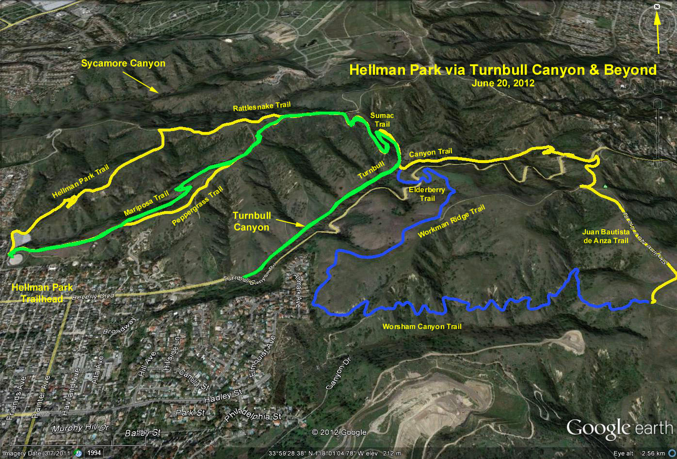
Basic hike: Hellman Park enables one to access the entire 4000 acres of the Native Habitat Preservation Authoritys lands extending from Whittier on the west to Powder Canyon on the southeast in Hacienda Heights. We have a choice of two main trails, one the Hellman Park Trail and the other the Peppergrass Trail. Both go steeply northeast. The Hellman Trail in 1.1 miles joins the Rattlesnake Ridge Trail, where a right turn brings you in 0.5 miles, to a point where you meet the Peppergrass Trail coming 1.25 mi up from the parking lot. From this junction go 0.2 mi. east on a level path to a junction with the Sumac Trail where we turn right and go down 0.6 mi to a junction with the Turnbull Canyon Trail. Turn left onto the Turnbull Canyon Trail, and in 0.6 mi. you will come to a junction with the Schabarum Trail coming down from your left. Continue straight ahead east on the Schabarum Trail, which in 0.4 mi crosses Turnbull Canyon Road and in a few feet makes a sharp right turn. In 0.2 mi you will cross under the Tehachapi Power Line and reach a road. Turn left on this road, part of the Juan Bautista De Anza Trail Historic Route; pass a little knoll on your left strewn with girder wreckage and in 0.5 mi come to a junction with the Worsham Canyon Trail. This is a good turn around point. Go back the way you came.
Alternate hike: Proceed as above to the junction of the Sumac and Turnbull Canyon trails, but turn right instead of left. Continue on the Turnbull Canyon trail until it ends upon reaching Turnbull Canyon Road. Return to the trailhead the way you came.
Those wanting a shorter hike could turn around at any place on the route. A stop for lunch would be ideal anywhere in the shade of Turnbull Canyon.
Refreshments will be served at the trailhead.
Google Earth Photo - Hellman Park, Turnbull Canyon & Beyond
GPS Data:
Basic Hike (yellow trace): RT = 8.2 mi.; max. elevation change = 880 ft.
Alternative Hike (green trace): RT = 6.1 mi.; max. elevation change = 640 ft.
Basic Hike + Extra loop (blue trace): RT = 9.4 mi.; max. elevation change = 880 ft.