Distance Basic Hike: 7 mi. RT
Max. Elevation Gain: 600 ft.
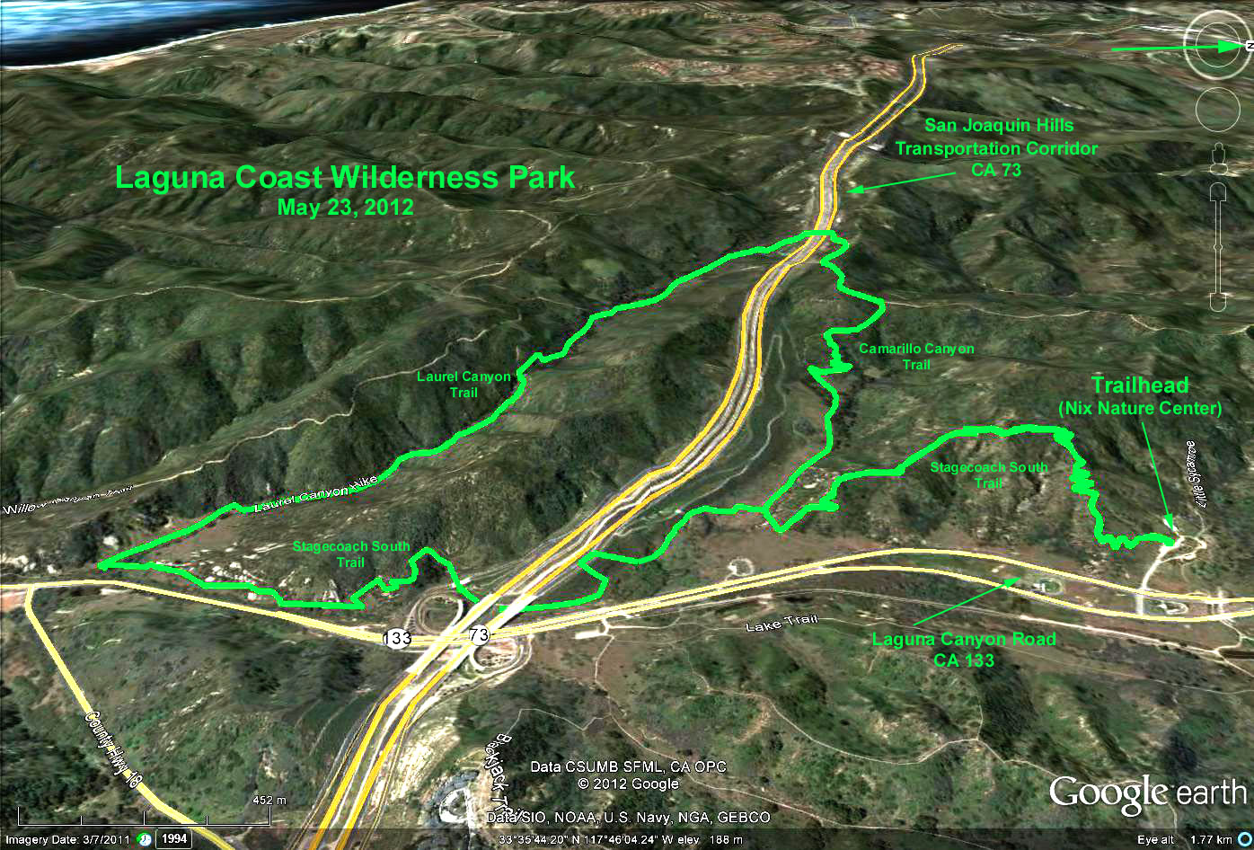
DIRECTIONS TO TRAIL HEAD: The trailheads are located by the parking lot close to the Nix Nature Center. Drive south down the I-405 or the I-5 freeway, and prior to their merger, exit south at Laguna Canyon Road, CA-133. Go south on the 133 about 3 miles from the 405 or about 4.5 miles from the 5, turn right into the parking lot for the Nix Nature Center. (If you go under the 73 (San Joaquin Transportation Corridor) you've gone too far). Rest rooms are available at the Nix Nature Center. The parking fee is $3.00 at an electronic fee collection box.
THE HIKE: Four hike alternatives are offered, all starting near the Nix Nature Center. The baseline hike is a pleasant 7 mile hike loop that includes brush and open areas, some mature oak tree sections, some boulders, some water/stream views, and a cave or two. This trail starts at marker 45 and goes south on the Stagecoach South Trail past marker 44. At marker 43, continue straight (west) on the Camarillo Canyon Trail/Road until marker 28. Turn left on the Serrano Ridge Trail, pass marker 27 and by Gate 21 under the San Joaquin TCA (Route 73). Continue left/southeast past marker 26 along the Upper Laurel Canyon Trail, past marker 10, now on the Laurel Canyon Trail, until marker 25. Turn left on Stagecoach South Trail going north, and follow this wandering trail eventually back under the 73 and back up to the intersection with the Camarillo Canyon Road/Trail by marker 43. Turn right, continuing back to the parking area/trailhead on the Stagecoach South Trail past markers 44 and 45.
The other three trail options all start near marker 46 by the Nix Nature Center. Take Mary's Trail or the Little Sycamore Canyon trail northwest until they shortly intersect again by marker 48, and head north on the Little Sycamore Canyon Trail until it intersects with the Serrano Ridge Trail by marker 29. The last part of this is noticeably uphill. The general terrain is unshaded with brush and low shrubs. Turn right (north) for an uphill walk on the Serrano Ridge Trail until Quail Trail. (A possible additional extension is to turn left (west) onto Quail Trail up to Rabbit Run. This last area has a nice view.) The total hike distance to Quail Trail is about 1.7 miles. We now return the way we came until we reach marker 29 again by the Little Sycamore Canyon Trail.
The short loop trail option returns to the trailhead at this point via the way we came, on Little Sycamore Canyon Trail - 3.5 mi. RT.
The intermediate loop trail option continues south on the Serrano Ridge Trail until it intersects near marker 28 with the Camarillo Canyon Road/Trail. Turn left (east) on the Camarillo Canyon Trail/Road until it intersects with the Stagecoach South Trail near marker 43. Continue straight (left) along the Stagecoach South Trail, past markers 44 and 45 and back to the parking area - 5 mi. RT.
The long loop trail option is the outer loop for the other three trails. Stay on the Serrano Ridge Trail past marker 28 (i.e., don't turn on the Camarillo Cyn Trail), and go southwest past marker 27 and under the 73 TCA. Follow the directions from the baseline hike from this point on until returning to the parking area - 9.4 mi. RT.
Google Earth Photo - Laguna Coast Wilderness Park
GPS Data:
Basic hike: 7.5 mi. RT
Max. Elevation change = 560 ft.