Basic Hike: RT = 7.5 mi.
Max. Elevation Change = 500 ft.
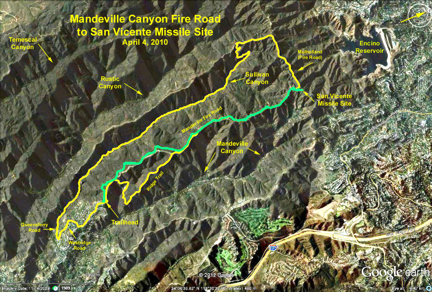
Directions to trailhead: Take the 405 freeway to Sunset Blvd. exit, proceed west on Sunset Blvd. about 3.2 miles to Mandeville Canyon Road. Turn right at the traffic light and go to the first stop sign, then left onto Westridge Road. Proceed to the end of Westridge which is the trailhead for the Mandeville Fire Road.
Basic hike: Take the fire road which leads to a Nike missile site that is on the Mulholland Fire Road. This is San Vicente Mountain Park. Tables and restrooms are available so this is a good place for lunch. Return by the same trail.
Alternative hike #1: Taking the trail that starts uphill to the right of the parking area, you'll soon find that has many more ups and downs than the fire road. It parallels the road, climbs a small peak and soon connects with the road at about 0.6 mi. from the trailhead. At this point, the trail descends off to the right into a ravine. Crossing the ravine and regaining the opposite ridge at about 1 mile from the trailhead there is a junction with a road turning sharply to the right that goes down into Mandeville Canyon - stay to your left on the trail eventually regaining the fire road in another 1.5 miles (may require some bushwhacking).
Alternative hike #2: Take the missile site access road down to Mulholland, and continue west on Mulholland until reaching the west ridge of Sullivan Canyon. Descend into the canyon and take it south down canyon 5.6 mi. to the Queensferry Road trailhead (look for large house up on the hill to your left with large statues of animals on the hillside). Continue south on Queensferry Road until it intersects with Westridge Road, turn left, and return to the trailhead.
Google Earth photo - San Vicente Missile Site from Mandeville Canyon Trailhead
GPS Data:
Basic Hile: 7.6 mi. RT; max. elevation change = 675 ft.
Alternate Hike #1: Adds 0.5 mi. to the 3.8 mi. one way to the missile site. Adds a 450 ft. loss and gain to the basic hike elevation change.
Alternative Hike #2: 11.4 mi. RT; max. elevation change = 1300 ft.