Distance - Basic Loop: 4.5 mi. RT, 900 ft. elevation gain
Extended Loop: 5.5 mi. RT, 1200 ft. elevation gain.
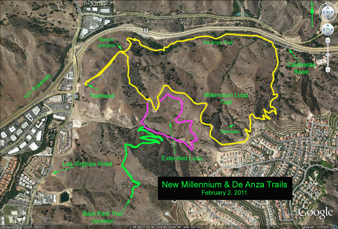
Summary: New Millennium Loop Trail is a new designation for an improved loop consisting of parts of the De Anza Trail, the old Gun Club Road, and some improved old trails. The De Anza trail is part of the original Camino Real or King's Road. The hike consists of a basic loop plus an an additional loop extending beyond the basic loop. A series of switchbacks leading off the extended loop is available to add mileage as an option.
Directions to Trailhead: Exit the Ventura (101) freeway onto Las Virgenes Road. There is a Mobil gas station about 0.1 mi south of the freeway at 4830 Las Virgenes, and a little stub of a road beside the station that leads to a large dirt parking lot. The road continues and leads up to a smaller parking area, and the actual trailhead. Either lot will work fine. There are no restrooms at the trailhead.
The Hike: The hike begins straight up the canyon to a junction where the slope levels for a saddle and a nice oak, complete with a bench. We will hike the loop clockwise, so stay left at the junction and trail sign. We are on the De Anza trail and soon traversing high above the freeway before dropping down to, and crossing a small steam bed. Hike along the trail/dirt road parallel to the freeway and under the power lines, to the East Trailhead, where the paved Calabasas Road ends, and is blocked by an elaborate steel gate. After another 100 yards, you will get you to a small paved stub off to the right that will eventually drop down to the creek. Come up out of the creek and turn right at the trail sign.
The trail climbs on the western slope, above the canyon, toward the distant houses on the crest. After a hard mile upward you will crest and there will be two small trail signs. Continue to a paved road parallelling the houses above, then turn right, and then continue for most of a mile on the old dirt road. At the signed junction stay on the road for the shorter loop, or turn left on the trail for the extended loop.
For the basic loop stay on the road until a second hairpin turn, when a small trail sign directs you to a trail on the right. Continue north on the trail to reach the hikes first junction, the bench, and ultimately the trailhead.
For the extended loop, the trail contours eastward and then westward down a wooded draw eventually reaching a small connector trail that branches off to the right down some railroad tie stairs soon reaching a dirt road. Turn right on the road and continue north-westerly up the road to the hairpin turn, where a small trail sign directs you northward on the trail back to the benchs junction. Turn left and return to the trailhead.
To extend the hike beyond the extended loop, instead of turning right to take the connector trail back to the road, climb southward up the switchbacks and proceed toward the Bark Park Trailhead, as far as you wish. Return the way you came using the small connector road to complete the extended loop as per above.
Refreshments at the trailhead
Google Earth photo - Millennium & DeAnza Trails
GPS Data:
Basic Loop (yellow trace): RT = 4.2 mi., max. elevation change = 560 ft.
Extended Loop (magenta trace): adds 1.1 mi one way, max elevation change = 670 ft.
Added mileage to Bark Park Trail junction (green trace): adds 2.2 mi. RT, max elevation change = 800 ft.