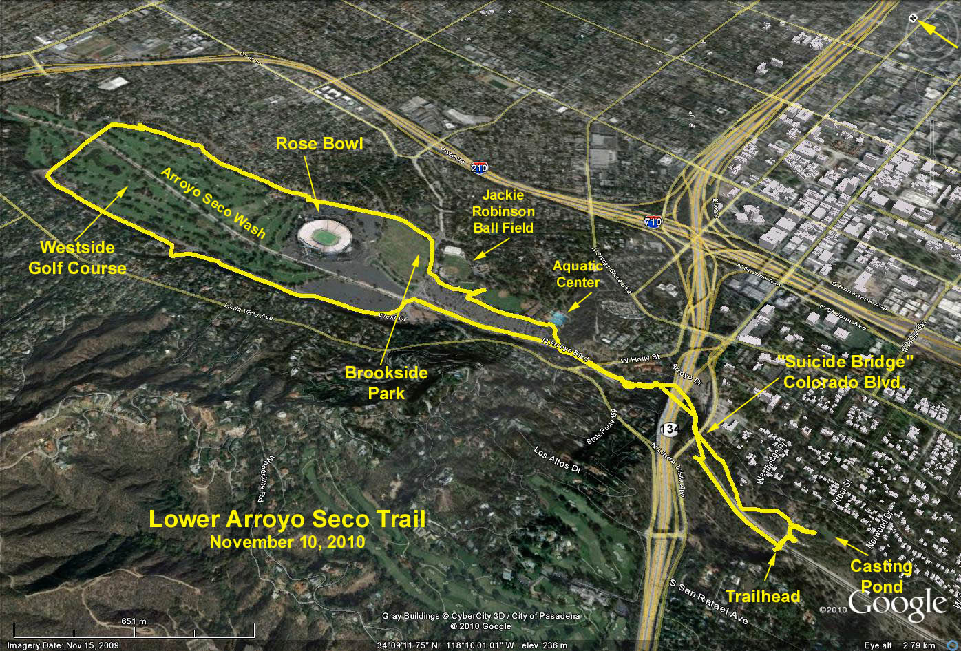
GPS Data:
RT = 6.1 miles
Max Elevation change = 235 ft.
Directions to Trailhead: Via the 134 eastbound: Exit at Orange Grove Blvd. At the top of the ramp, turn right (south) on Orange Grove Blvd. to California Blvd. Turn right (west) on California Blvd. until it dead-ends at Arroyo Blvd. Turn right (north) and after 0.2 mile look for a driveway to the left with a triple sign: "Lower Arroyo Park, Pasadena Roving Archers, Pasadena Casting Club" and proceed down the narrow driveway to the un-paved parking lot on the left.
Via the 210 eastbound: Continue on the 210 (beyond the usual off-ramp transition to the continuation of the 210 eastbound) until the freeway ends at California Blvd. Do not take the Colorado Blvd. option on your left. Turn right and follow the directions given above.
Via the 210 westbound: Exit at Orange Grove Blvd. At the top of the ramp, turn left (south) and follow the directions given above.
Via the 110 northbound (Pasadena Fwy.): Exit at Orange Grove Blvd. and turn left (north) on Orange Grove Blvd. and follow the directions given above.
The Hike: The hike proceeds north on the Lower Arroyo Seco trail along the east side of the Arroyo Seco wash. The trail passes under the famous suicide bridge (Colorado Blvd.), then under the double 134 freeway bridges - all 3 bridges beautiful arches - eventually ending at Seco St. This is the beginning of Brookside Park which contains the Rose Bowl Stadium and the Westside Golf Course. Further access to the Arroyo Seco wash is denied at this point so carefully cross the intersection and skirt around to the left, crossing over the wash and finding a dirt trail continuing north on the left side of West Dr. (alternatively, use the paved designated walking path on the right side of West Dr. running along the fence). Note this intersection for the return trip.
Beyond the Rose Bowl, the Westside Golf Course begins. Continue north on West Dr. until reaching the end of the golf course, turn right on West Washington Blvd. crossing over to North Arroyo Blvd. Turn right and follow North Arroyo Blvd south past the club house and the Rose Bowl eventually getting back to Seco St. (Look for a dirt trail running along the east side of Arroyo Blvd. rather than walking on the pavement).
Turn right on Seco St., cross it, and proceed to the intersection noted above. Turn left on the dirt path retracing your steps south, parallelling North Arroyo Blvd. passing the Jackie Robinson baseball fields, a number of picnic tables arranged in a square - a great place for lunch, and the Aquatic Center. Beyond the Aquatic Center, hikers will have to return to walking south along the wash. Look for the beginning of the trail off to the right continuing through large bushes along the stream just before reaching the first 134 fwy. bridge crossing high overhead. Take this trail back to the parking lot.
Alternate Hikes: Hikers can return to Arroyo Blvd. and use city streets to view the magnificant homes, go up to Colorado Blvd. check out the Norton Simon Art Museum, etc.
Refreshments served near the casting pond facility (which has restrooms) just east of the parking lot.